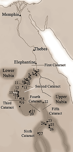
Key to Map of Nubia
1 - Dakka
C-Group Site (C-Group
people first appeared in Nubia at the time of the 6th Dynasty
of Egypt)
2 - Quban
Fortress and base for
mining operations (mines included the gold mines at Wadi el-Allaqi
and Wadi Gabgaba, the copper mines at Abu Segal and diorite quarries
in the desert west of Toshka) - time of Sesostris I (12th Dynasty).
3 - Wadi
es-Sebua
Fortified C-Group settlement.
4 - Sayala
Includes the grave of
a chief (?) from an A-Group Settlement.
5 - Aniba
C-Group site (also includes
an important cemetery dating to the period)
6 - Toshka
Diorite quarries
7 - Faras
A site occupied throughout
the ancient period, it contains an A and C-Group cemetery, it
was an important administrative centre of Egypt in Nubia in the
18th Dynasty (also in the Late Period)
8 - Qustul
A-Group cemetery, also
burials of Kings dating to the early Christian era.
9 - Buhen
Middle Kingdom fortress
site (although the site did originally flourish in the 4th and
5th Dynasties), copper was also smelted here, the site was re-used
by rulers of the New Kingdom
10 -
Wadi Halfa
Considered a strategic
position by the ancient Egyptians. Inscriptions here date to
the Nubian campaigns of Sesostris I. Another stela dates to the
19th Dynasty which celebrates the building of a temple to Horus.
In many eras of ancient Egypt, Wadi Halfa marked Egypt's southern
border.
11 -
Mirgissa
A fortress in the Middle
Kingdom, used as a port for the transport of goods from Nubia
to Egypt.
12 -
Batn el-Hagar
Called 'Belly of Stones'
by the local inhabitants, a desolate region of Nubia which extends
for more than 100 miles - the river is filled with rapids which
is matched by wasteland on the shore - a natural defence for
the region.
13 -
Semna
Frontier of Egyptian
control under Sesostris I and Sesotris III
14 -
Amara West
Town, walled with a stone
temple - for a time the residence for the Viceroy of Kush.
15 -
Sai
Island on the Nile, an
important Kushite settlement, as such this was garrisoned by
Egyptian troops during the reign of Tuthmosis I.
16 -
Sedeinga
Amenhotep III built 'an
impressive temple' here in honour of his Chief Queen Tiye.
17 -
Soleb
Amenhotep III built a
temple here solely for the worship of himself - a pair of red
granite lions stood by the temple (these now reside in the British
Museum), inscriptions on the lions link Amenhotep III as the
father of Tutankhamun.
18 -
Sesebi
Walled town, with stone
temple - also used for the residence of the Viceroy of Kush
19 -
Kerma
Large and important site
- Centre of Kushite Power - one of the earliest settlements in
tropical Africa. Evidence has been found of the first activity
of the site in the 4th millennium BC, graves date to 2,400BC
and then had constant development for the next 1,000 years. The
town had a large religious structure / temple as its focal point
(in 1750-1600BC this also had workshops and other religious buildings
within the temples quarter). Mud brick walls and dry ditches
protected the town. Craftsmen skilled in metal working, woodworking,
ceramics, Jewellery etc were housed at Kerma. Tuthmosis I attacked
and sacked the town - the outer defences were demolished by him
(it is thought to stop Kerma becoming a focal point for Nubian
uprising against the Egyptians).
20 -
Napata
Frontier settlement,
built by Tuthmosis III - this marked the entry point for goods
entering Egypt from the rest of Africa at this point in time.
In the 8th Century BC a new and powerful Kushite kingdom emerged
in the region of Napata, this was to go on to become the greatest
civilisation of Nubia. The first period of this development took
place in the Napata Period (it would then continue to become
the Merotic Period following a break-away from Egyptian culture).
This Kushite Kingdom would gain in power and whose descendants
would eventually become pharaohs of Egypt (25th Dynasty). Rulers
of Kush were buried in pyramids at Nuri, close to Napata.
21 -
Gebel Barkal
'Flat Topped Mountain'.
The most important religious centre in Nubia during the New Kingdom
- called 'Holy Mountain' by the Egyptians. It became the Nubian
centre for the cult of Amun, many temples were built at the base
of the mountain.
22 -
Kurgus
Furthest point that Tuthmosis
I reached in his campaigns into Nubia
23 -
Meroe
The chief city of Nubia
in the 6th century BC (although it was used as a royal residence
as early as the 8th century BC), the rulers of Nubia were buried
here in steeply sided pyramids. From the beginning of the 3rd
Century BC there was a gradual shift away from the pharaonic
influence of Egypt, it was then that the royal burials became
to be placed at Meroe than at the cemetaries close to Napata.
The town of Meroe has only been partly excavated, but a great
temple to Amun has been found which had an avenue of rams. In
the 8th century BC a new and powerful Kushite Kingdom emerged
in Napata, this was to become the greatest civilisation of ancient
Nubia - the Kingdom of Meroe (the Merotic Period) - it was to
exist for over a thousand years (although the major events were
to take place in the first half - the Napata Period).
24 -
Wad Ban Naga
Important trade centre
25 -
Musawwarat es-Sufra
The site of the 'Great
Enclosure' - an area which included temples and a complete arrangement
of courts, rooms and passages. Decoration includes sculptures
of elephants - it is thought that this 'Great Enclosure' may
have been a place for pilgrimage and / or a royal residence.
26 -
Naga
Location of temples.
27 -
Kadero
Important early site
in Nubia - as early as 4,000BC there is evidence of the domestication
of cattle and cultivation of cereal crops as well as hunting
and gathering.